Introduction
In today’s digital age, exploring the world has never been easier, thanks to the Google Earth Map App. Available for both Android and iPhone, this powerful tool allows users to virtually travel anywhere on the planet, view stunning 3D imagery, and discover new places with just a few taps. Whether you’re a travel enthusiast, a student, or a professional, Google Earth offers a unique and immersive way to explore the world. In this article, we’ll dive into the features, benefits, and uses of the Google Earth Map App, and how you can make the most of it on your mobile device.
What is the Google Earth Map App?
Google Earth is a geospatial application developed by Google that provides detailed 3D maps and satellite imagery of the Earth. The app allows users to explore cities, landmarks, natural wonders, and even outer space. With its intuitive interface and advanced features, Google Earth has become a go-to tool for education, travel planning, and exploration.
Key Features of the Google Earth Map App
The Google Earth Map App is packed with features that make it a must-have for anyone curious about the world. Here are some of its standout capabilities:
1. 3D Satellite Imagery
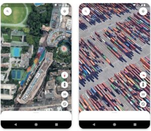
Google Earth offers high-resolution 3D satellite imagery, allowing users to explore cities, landscapes, and landmarks in stunning detail.
2. Street View Integration
The app integrates Google Street View, enabling users to take virtual walks through streets and neighborhoods around the world.
3. Voyager
Voyager is a guided tour feature that offers interactive stories and tours curated by experts. It covers topics like nature, culture, history, and travel.
4. Measure Distance and Area
Google Earth includes a measurement tool that lets users calculate distances between locations and measure the area of specific regions.
5. Time-Lapse Imagery
The app provides time-lapse imagery, showing how the Earth’s surface has changed over the past few decades due to natural and human activities.
6. Explore the Ocean and Space
Google Earth allows users to dive into the ocean’s depths and explore marine life or venture into space to view planets and constellations.
7. Offline Maps
Users can download maps for offline use, making it convenient for travelers who may not have internet access.
8. Cross-Platform Sync
Google Earth syncs across devices, allowing users to save favorite locations and access them on any device.
Benefits of Using the Google Earth Map App
Using the Google Earth Map App offers numerous benefits for individuals and professionals alike. Here are some of the key advantages:
1. Virtual Travel
Google Earth allows users to explore the world from the comfort of their homes, making it an excellent tool for travel enthusiasts and students.
2. Educational Tool
The app is a valuable resource for educators and students, providing interactive ways to learn about geography, history, and environmental changes.
3. Travel Planning
Users can plan trips by exploring destinations, checking out landmarks, and getting a feel for the layout of cities and towns.
4. Environmental Awareness
Google Earth’s time-lapse feature raises awareness about environmental changes, such as deforestation, urbanization, and climate change.
5. Professional Use
Professionals in fields like real estate, urban planning, and tourism can use Google Earth to analyze locations and present data visually.
How to Use the Google Earth Map App
Using the Google Earth Map App is simple and intuitive. Here’s a step-by-step guide to get started:
Step 1: Download the App
- Visit the Google Play Store (for Android) or App Store (for iPhone).
- Search for Google Earth and download the app.
Step 2: Explore the Interface
- Open the app and familiarize yourself with the interface.
- Use the search bar to find specific locations or browse the map manually.
Step 3: Navigate the Map
- Use your fingers to zoom in and out, rotate, and tilt the map for a 3D view.
- Tap on locations to view more details and photos.
Step 4: Use Advanced Features
- Try the Voyager feature for guided tours.
- Use the Measure Tool to calculate distances and areas.
- Explore Time-Lapse Imagery to see changes over time.
Step 5: Save and Share
- Save your favorite locations for easy access later.
- Share interesting finds with friends and family via social media or messaging apps.
Practical Applications of Google Earth
The Google Earth Map App has a wide range of applications across various fields:
1. Education
- Teach students about geography, history, and environmental science using interactive maps and tours.
- Create virtual field trips to explore distant locations.
2. Travel Planning
- Research destinations, hotels, and attractions before booking a trip.
- Get a sense of the layout of a city or neighborhood.
3. Real Estate
- Explore properties and neighborhoods remotely.
- Showcase properties to clients using 3D imagery.
4. Environmental Monitoring
- Track changes in land use, deforestation, and urban development over time.
- Raise awareness about environmental issues.
5. Urban Planning
- Analyze land use patterns and plan infrastructure projects.
- Visualize proposed developments in 3D.
Tips for Getting the Most Out of Google Earth
Here are some tips to enhance your Google Earth experience:
- Use Layers: Enable layers like borders, roads, and photos to add context to your exploration.
- Explore Hidden Gems: Use the “I’m Feeling Lucky” feature to discover random interesting locations.
- Create Projects: Use the Project Creation Tool to create custom maps and stories.
- Stay Updated: Regularly update the app to access new features and improvements.
Conclusion
The Google Earth Map App for Android and iPhone is a powerful tool that brings the world to your fingertips. With its stunning 3D imagery, interactive features, and educational value, it’s an essential app for anyone curious about the planet. Whether you’re planning a trip, teaching a class, or simply exploring for fun, Google Earth offers endless possibilities for discovery. Download the app today and start your journey of exploration!